Destructive flood event in Thessaly, Greece, September 2023
Download Factsheet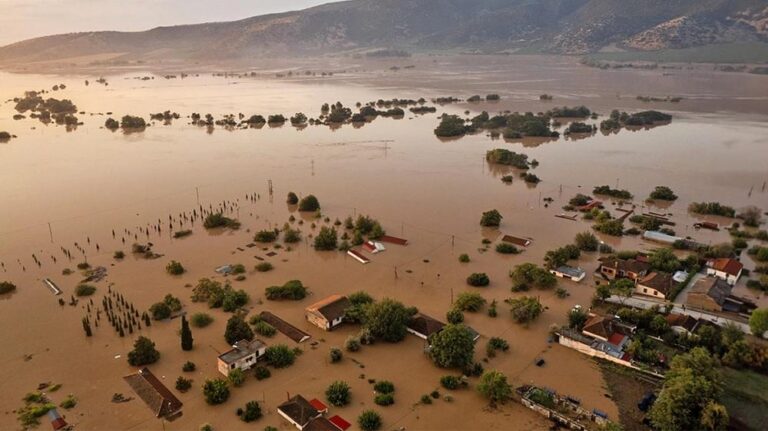
Event Type
Flood
Start Date
4 Sep 2023
Countries
- Greece
NUTS
- Thessalia (EL61)
RBD
- Greece - THESSALIA (EL08)
Duration (hours)
96
Event severity
HIGH
Event extent
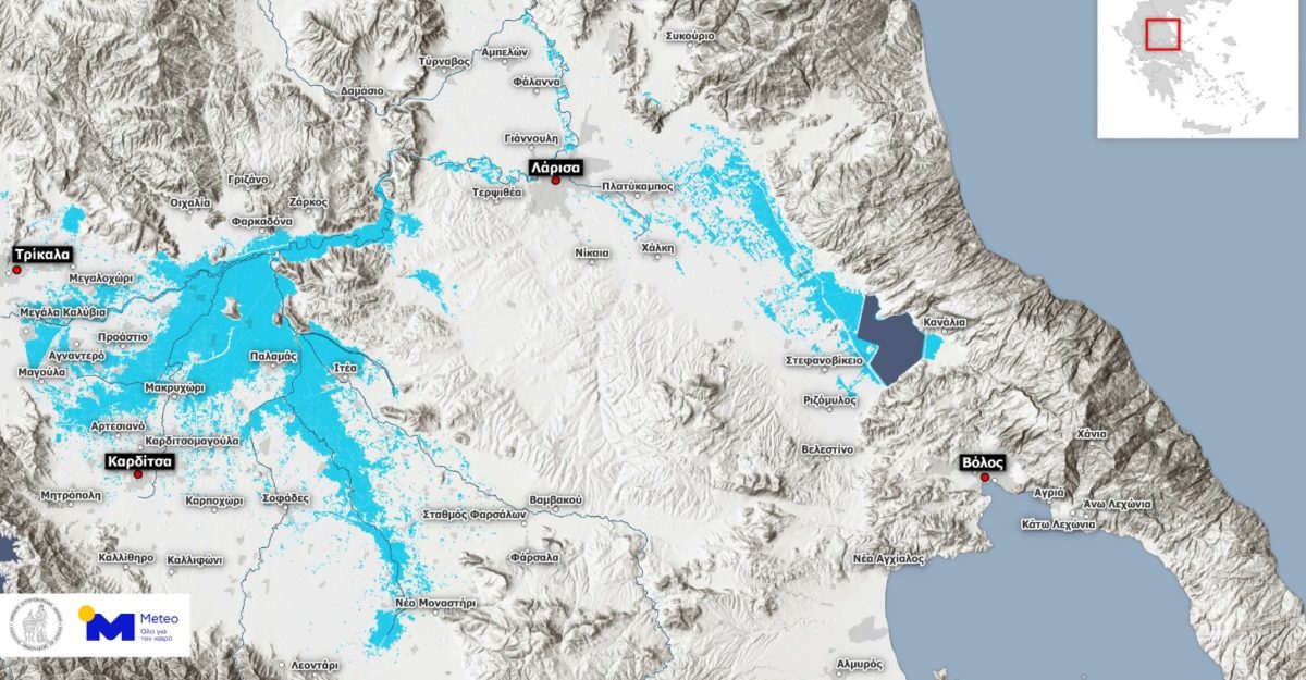
1300.0 km2
Event Severity Assessment Method
This was one of the worst flood events in Greek history, classified as a catastrophic event with 17 fatalities. The severity was assessed through satellite imagery (e.g., Copernicus EMS), rainfall data, and field damage reports. Rainfall peaked at 900 mm in parts of the region over 48 hours, leading to overwhelming floods.
Impact Significance
HIGH
Event Description
In September 2023, the Thessaly region of Greece experienced catastrophic flooding after the storm "Daniel" brought unprecedented rainfall. Over several days, torrential rains inundated towns and villages, leading to severe flooding across an area of approximately 1,300 square kilometers. The floods claimed at least 17 lives, displaced thousands, and caused extensive damage to homes, infrastructure, agriculture, and livestock. The region, a key agricultural hub, faced billions of euros in losses, with contaminated water supplies and damaged roads further complicating recovery efforts. The disaster highlighted the vulnerability of infrastructure and communities to extreme weather events.
Emergency Response Measures
The Greek government allocated €600 million for emergency response and immediate relief. The Greek military and emergency services conducted widespread evacuations and relief operations, rescuing over 5,000 residents from flooded areas.
Mitigation Measures
Financial assistance: Immediate financial assistance has been provided. By April 2024, the Ministry of Climate Crisis and Civil Protection had disbursed approximately €173.8 million to 48,841 households, businesses, agricultural enterprises, and livestock units affected by the floods (of which €80 million distributed to flood-affected households for property repairs). In September 2024, Prime Minister announced a substantial allocation exceeding €3 billion for the recovery of Thessaly. This funding encompasses support for agricultural restoration, infrastructure rebuilding, and flood protection projects. Infrastructure rehabilitation and Flood defense projects: Repairs and reinforcement of damaged infrastructure, including roads, bridges, and flood defenses, to restore functionality and prevent further damage. In September 2024, four new anti-flooding projects commenced across the four prefectures of Thessaly—Karditsa, Trikala, Larissa, and Magnesia—at a total cost of €75 million. These projects aim to strengthen existing flood defenses and improve water management systems
Long Term Adaptation Measures
There are plans to invest in nature-based solutions, such as restoring wetlands and widening riverbeds to enhance flood resilience. The city of Trikala has committed €7 million to such initiatives, with a focus on restoring damaged rivers and wetlands to absorb future floodwaters Master Plan Development: A master plan with interventions for restoration and anti-flooding measures, as well as solutions for sustainable irrigation in agricultural and livestock production.
Sources
https://earthobservatory.nasa.gov/images/151816/greeces-agricultural-heartland-underwater https://earthobservatory.nasa.gov/images/151807/a-deluge-in-greece https://emergency.copernicus.eu/mapping/list-of-components/EMSN184
Impact Types, Subtypes, and Indicators
Environmental
Subtype: Reduced surface water availability
Severity: Medium
Indicators:
- Reduction in reservoir levels (cm): 20.0
Subtype: Water quality deterioration (eutrophication, turbidity, contamination, pollutants, heavy metals, increased toxicity, etc.)
Severity: High
Indicators:
- Increased contamination/pollutants levels in water sources (mg/L increase): N/A
- Nutrient loading (kg/km2): N/A
- Volume of debris generated (tonnes): 400000.0
- Changes in turbidity (Nephelometric Turbidity Units – NTU increase): 25.0
Subtype: Biodiversity and Habitat loss and/or degradation (reduction and degradation of fish and wildlife habitat, damage to animal species, damage to plant species, etc.)
Severity: High
Indicators:
- Number of species affected, lost or displaced (number): 200.0
- Loss of habitat (km2): 15.0
- Wetland loss or alteration (km2): N/A
- Forest and/or vegetation cover loss (km2): 50.0
- Aquatic species or fish mortality (tonnes): 25.0
Subtype: Land and Soil degradation, including landslides
Severity: Very High
Indicators:
- Inundated area (km2): 7000.0
- Area of farmland rendered unusable (km2): 850.0
- Sediment deposition in floodplains (cm): 15.0
Societal and Cultural
Subtype: Displacement and Housing
Severity: High
Indicators:
- Number of people displaced (number): 10000.0
- Number of houses damaged or destroyed (number): 90.0
Subtype: Disruption in community services and education
Severity: Medium
Indicators:
- Number of community services disrupted (e.g., water, electricity) (number): N/A
- Duration of transportation disruption (days): 30.0
- Number of health care facilities damaged or destroyed (number): N/A
- Length of roads and bridges damaged (km): 180.0
Subtype: Disruptions and/or shortages in water supply
Severity: High
Indicators:
- Population without access to clean water after the event (number of people): 250000.0
- Duration of water supply disruption (days): 15.0
Subtype: Water-related conflicts (between e.g. public authorities, sectoral stakeholders, water users)
Severity: Medium
Indicators:
Subtype: Damage to landscapes and recreational areas
Severity: Medium
Indicators:
Subtype: Loss of Cultural or Spiritual heritage
Severity: Medium
Indicators:
- Number of cultural heritage sites damaged (number): N/A
- Number of disrupted cultural events (number): 20.0
Subtype: Impacted population
Severity: High
Indicators:
- Number of people impacted (number): 150000.0
Economic
Subtype: Residential property damages (households)
Severity: Very High
Indicators:
- Total monetary value of residential (households) property damage (euros): 2000000000.0
Subtype: Commercial and industrial properties damages
Severity: High
Indicators:
- Total monetary value of commercial and industrial properties damage (euros): N/A
Subtype: Public/ Community buildings and infrastructure damage
Severity: Very High
Indicators:
- Total monetary value of damages in roads and bridges (euros): 500000000.0
Subtype: Direct Agricultural and Livestock losses
Severity: Very High
Indicators:
- Crop yield losses (tonnes): N/A
- Monetary value of crop yield losses (euros): 1500000000.0
- Livestock losses (number of animals): 112000.0
- Monetary value of livestock losses (euros): 300000000.0
- Agricultural area affected (km2): 1100.0
Subtype: Lost income in Agriculture
Severity: Very High
Indicators:
Subtype: Lost income in Industries
Severity: Medium
Indicators:
Subtype: Lost revenue in Tourism
Severity: High
Indicators:
- Lost revenue in tourism (euros): 30000000.0
Subtype: Public spending for emergency response and mitigation
Severity: Very High
Indicators:
- Government expenditure on emergency response (euros): 600000000.0
- Government expenditure on mitigation measures (euros): N/A
- Subsidies or financial aid provided for households (euros): 80000000.0
Subtype: Economic damage
Severity: Very High
Indicators:
- Total economic damage across sectors (euros): 3500000000.0
Health
Subtype: Fatalities and injuries caused
Severity: High
Indicators:
- Number of fatalities caused by the event (number of deaths): 17.0
- Number of injured people (number): N/A
Subtype: Incidence of waterborne diseases (e.g., cholera, typhoid, dysentery)
Severity: Medium
Indicators:
Subtype: Impacts on mental health
Severity: Very High
Indicators:
- Number of individuals reporting related psychological distress (number): 20000.0
Subtype: Respiratory and/or heat-related health Impacts
Severity: Medium
Indicators:
Subtype: Access to healthcare
Severity: High
Indicators:
- Increase in hospital admissions (number of admissions): 800.0
- Population unable to access healthcare (%): 30.0
Subtype: Health issues due to contaminated water
Severity: High
Indicators:
- Number of cases with health issues due to contaminated water (e.g. gastrointestinal issues) (number): 500.0
Impact Types
- Environmental
- Health
- Societal and Cultural
- Economic
Impacted Sectors
- Residential and Commercial
- Agriculture
- Livestock
- Tourism & Recreation
- Industry
- Energy
- Infrastructure (roads, water supply, etc.)
- Public Health
- Forestry
- Plants & Wildlfe
Reference Point
39.54928676339433,22.210056142725527
Data Managers
Maggie Kossida (SEVEN), Anthi Manali (SEVEN)
Last Updated
1 Sep 2025, 10:55 p.m.